River

Warby, Killawarra & Lurg Hills Revegetation Zone

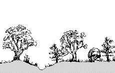
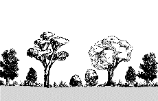
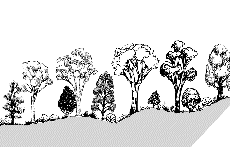
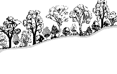
The vegetation profiles represent a generalised picture of the landscape. Each profile presents a typical landscape sequence. For each landform the following information is listed:

  • a schematic drawing showing the vegetation structure;
  • the main Ecological Vegetation Classes (EVCs) associated with it;
  • a brief description of the vegetation;
  • a brief description of the associated geology and soils;
  • one or two location examples where intact native vegetation can be observed (if known);
  • a link to a list of plant species grouped into trees, shrubs and groundcovers that are local to the area, suited to similar sites and can be used as a guide for planting projects.

It should be noted that the landforms presented may occur in different sequences in some areas. The profiles have been compiled to represent typical sequences, but these may not be the only ones.

To assist you to identify the appropriate vegetation profile and species list, Understanding Your Planting Profile , is suggested as a first step.


Use the profile name and descriptions to determine the ones most suited to your site. Click on the landform name to view the species list.


The vegetation in the Warby, Killawarra & Lurg Hills Revegetation revegetation zone has been divided into five profiles containing different vegetation types.

Killawarra/Chesney Sedimentary Hills & Slopes

Creeklines

 
Geology Alluvial sediments; sand, clay and silt soils.
EVC Creekline Grassy Woodland
Description River Red Gum woodland on banks of small intermitten creeks, with a scattered tall to medium shrub layer and dense ground layer of grasses and sedges.
Examples Katamatite Creek, north of Thoona Rd.
Species List Creeklines species list

Broad Alluvial Drainage Lines/Creek Flats

 
Geology Alluvial sediments, often poorly drained soils with sandy loam overlying clay subsoil.
EVC Alluvial-terraces Herb-rich Woodland
Description Open Red Gum and Box Woodlands on ephemeral drainage lines and adjacent alluvium plains. Understorey consists of a sparse medium to tall shrub layer with a diverse species rich ground layer of annual and perennial grasses and herbs.
Species List Broad Alluvial Drainage Lines/Creek Flats species list

Low Hills

 
Geology Sedimentary, sandy loam to clay loam soils.
EVC Grassy Woodland (Low Rises and Rainshadow)
Description Grey Box and White Box dominated woodland with an open mid-storey of wattles, and diverse grassy and herbaceous ground layer.
Examples Angford Rd, north edge of Killawarra.
Species List Low Hills species list

Stony/Gravelly Hills

 
Geology Sedimentary, skeletal sandy loam to clay loam soils, often gravelly.
EVC Box Ironbark Forest
Description Open forest of Box, Stringybark and Ironbark eucalypts. Understorey often forms an open shrub layer over an open ground layer ranging from a sparse to well-developed suite of herbs and grasses.
Examples Boweya Flora and Fauna Reserve, Goorambat
Species List Stony/Gravelly Hills species list
Return to profiles index


Warby Ranges Upper Slopes

Valleys

 
Geology Colluvium derived from various geologies. Soils range from clays and sands to welll drained red brown soils.
EVC Valley Grassy Forest
Description Open forest in fertile, gently sloping valleys of the surrounding dry foothills, with a tall open shrub layer and a dense ground layer of grasses and herbs.
Examples Gully crossed by Adams Rd, Warby-Ovens National Park.
Species List Valleys species list

Dry Slopes (South facing)

 
Geology Granitic or sedimentary, typically shallow soils.
EVC Grassy Dry Forest
Description Open forest on south-facing steep dry slopes with a grass-dominated ground layer and a sparse shrub layer.
Examples Adams Rd, south of Tower Rd.
Species List Dry Slopes (South facing) species list

Ridges, Exposed Slopes (North facing) and Plateaux

 
Geology Granitic or sedimentary, skeletal sandy loam soils.
EVC Heathy Dry Forest
Description Open eucalypt forest of Red Stringybark, Red Box and Long-leaf Box. The understorey is dominated by low growing heaths and peas, with a sparse ground layer of herbs and grasses.
Examples South side of Thoona Rd, Warby Range.
Species List Ridges, Exposed Slopes (North facing) and Plateaux species list
Return to profiles index


Granite Hills & Slopes

Wet Depressions

 
Geology Granitic colluvium, poorly drained clays and silts, usually moist through summer
EVC Spring Soak Woodland
Description Woodland sometimes treeless, often a patchy shrub layer dominated with Prickly Tea-tree over a ground layer of sedges, rushes, ferns and a diversity of herbs.
Examples Black Springs on Nightjar Track, Warby-Ovens National Park.
Species List Wet Depressions species list

Gentle Slopes of Granitic Outwash

 
Geology Granitic colluvium, sandy loam soils.
EVC Grassy Woodland (shrubby granitic outwash)
Description Blakely's Red Gum, Red Stringybark and Red Box woodland with an open mid-storey of wattles, and a grassy ground layer dominated with Cane Wire-grass.
Examples Bushland Reserve on Old Thoona Rd, Lake Rowan Cemetery.
Species List Gentle Slopes of Granitic Outwash species list

Rocky Outcrops

 
Geology Granitic outcrops.
EVC Rocky Outcrop Shrubland/Herbland Mosaic
Description Sparse to dense heathy shrubland, interspersed with areas of exposed rock covered by a diversity of herbs, mosses and lichens, with the occasional stunted Blakely's Red Gum or Drooping Sheoak.
Examples Pangarang Lookout, Warby-Ovens National Park.
Species List Rocky Outcrops species list

Granite Hills and Slopes

 
Geology Granitic, sandy to sandy loam soils, often shallow.
EVC Granitic Hills Woodland
Description Open woodland dominated by Blakely's Red Gum (at times stunted by poor soil), with a medium shrub layer and rich herbaceous ground layer.
Examples North and West faces of Mt Meg, Mt Bruno.
Species List Granite Hills and Slopes species list
Return to profiles index


Lurg Hills & Valleys

Creeklines and Fertile Gullies.

 
Geology Alluvial and colluvial. Loamy soils with sandy patches.
EVC Valley Grassy Forest
Description Open forest in fertile, gently sloping gullies surrounded by dry foothills. Understorey consists of a tall open shrub layer and a dense ground layer of grasses and herbs.
Examples Greta Rd East of Sudholz Rd.
Species List Creeklines and Fertile Gullies. species list

Granitic Slopes

 
Geology Igneous with coarse granitic sandy soils, shallow to medium in depth.
EVC Granitic Hills Woodland
Description Open woodland dominated by Blakely's Red Gum (at times stunted by poor soil), with a medium shrub layer and rich herbaceous ground layer.
Examples Bush Reserve opposite Glenrowan Primary School.
Species List Granitic Slopes species list

Dry Slopes

 
Geology Sedimentary or Igneous (granite) rock. Soils shallow to medium in depth.
EVC Grassy Dry Forest
Description Open forest on dry slopes, with an understorey dominated by grasses, herbs and a few scattered shrubs.
Examples Grant Rd E of Winton-Lurg Rd; Hill top, Kennedy La Reserve.
Species List Dry Slopes species list

Ridges and Exposed Slopes

 
Geology Sedimentary and Igneous (granite) rock. Soils shallow to medium in depth.
EVC Heathy Dry Forest
Description Open forest of Red Stringybark, Red Box and Long-leaf Box found on ridges and exposed northerly slopes. The understorey is dominated by low growing heaths and peas, with a sparse layer of herbs and grasses.
Examples Western slope, Kennedy La Reserve; Roadside verges, Stanley Drive.
Species List Ridges and Exposed Slopes species list
Return to profiles index


Lurg Low Hills & Plains

Creeklines

 
Geology Alluvial, with soils ranging from sandy loam to silty clay.
EVC Creekline Grassy Woodland
Description River Red Gum and Yellow Box woodland on banks of small creeks, with a scattered tall to medium shrub layer and dense ground layer of grasses and sedges.
Examples Greta Rd at bridge 1km E of Embling Rd.
Species List Creeklines species list

Plains

 
Geology Alluvial, with clay loam soils.
EVC Plains Grassy Woodland
Description Open woodland on the plains dominated by Grey Box and River Red Gum, with a scattered shrub layer and dense suite of grasses and herbs.
Examples Coleman Road both verges; Bush Reserve beside railway line, 2km W of Glenrowan-Boweya Rd.
Species List Plains species list

Colluvial Outwash Slopes

 
Geology Sandy loam or clay loam soils.
EVC Box Ironbark Forest (Grey Box - Mugga Ironbark)
Description Open forest of Grey Box and Ironbark. Understorey often has an open shrub layer and an open ground layer ranging from a sparse to well-developed suite of herbs and grasses.
Examples Embling Rd 1km S of Greta Rd; Winton-Lurg Rd S of Coleman.
Species List Colluvial Outwash Slopes species list

Low Stony Gravelly Hills

 
Geology Sedimentary or contact metamorphic, with stony or gravelly clay soils.
EVC Box Ironbark Forest (Red Box - Mugga Ironbark)
Description Open forest of Red Box and Mugga Ironbark. Understorey often forms an open shrub layer over an open ground layer of sparse herbs and grasses.
Examples Old Lurg School bush reserve; Brock Rd W of Winton-Lurg Rd; Sudholz Rd, last rise at S end; Old Lurg Rd at Exton's quarry; Webster Rd N of Old Lurg Rd.
Species List Low Stony Gravelly Hills species list
Return to profiles index

Back to top