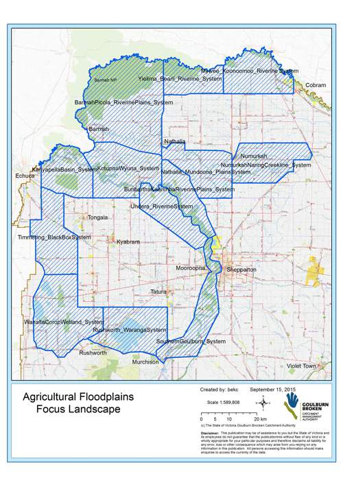
The Goulburn Broken CMA uses resilience thinking in its strategic planning. Resilience thinking focuses on the connections between people and nature, how these change and how to achieve our goals. This approach recognises social-ecological systems (SES) as strategic planning areas. In one of these SES (the highly productive Agricultural Floodplains) we recognised vegetation extent as one of five critical attributes that interact as components of a functioning system.
Importance of biodiversity in an irrigated landscape
The region is well-placed in terms of agricultural production, but this places heavy demands on the underpinning natural resource base of soils, water, and biodiversity ( native vegetation extent). Clearing (direct removal), degradation and non-regeneration of native vegetation (eg. paddock trees) are the biggest threat to native vegetation extent. A reduction in native vegetation extent and associated biodiversity, impacts on our long-term productive capacity, as well as the environment. For example, many insect-eating birds that benefit crops and pastures are largely absent without shrubs and natural ground layers. Native vegetation is also nature’s water purifier, reducing the risk of large loads of sediments and nutrients from entering our waterways.
Increasing native vegetation extent in an irrigated landscape using landscape scale planning
- Building upon existing native vegetation
Our landscape-scale approach uses the existing native vegetation as the basis to build upon, through protecting, enhancement, and revegetation (eg. corridors). This region has many key native vegetation areas such as along waterways and natural depressions, roadsides, public land reserves/national parks (eg. Goulburn River, Broken Boosey, Lower Goulburn, Barmah, and the Murray River), wetlands (eg. Reedy Swamp, Doctors Swamp, Bray’s Swamp and Kinnaird’s Wetland), and on private land (eg. paddock trees and remnants). Native vegetation extent includes all vegetation layers (eg. grasslands, wetlands, shrubs, and overstorey).
- Prioritising key action areas (landscapes)
To improve the native vegetation extent and improve resilience the following aspects were considered in determining landscapes to target for action:
- smaller landscape scale areas that are small enough to understand and manage the critical details, yet large enough to allocate resources efficiently; and
- common landscape characteristics such as environmental sustainability (e.g. landscape context), economic sustainability (e.g. land use type) and social sustainability (e.g. existing community networks).
As a result, 13 priority landscapes across the Agricultural Floodplains were identified to target for native vegetation extent projects (targeted but not excluding other areas).

- Determining targets for native vegetation extent (thresholds for change)
Understanding system resilience (and thresholds) drives our decision making in setting revegetation targets for increasing native vegetation extent across our prioritised landscapes. Research examining woodland birds’ responses to landscape change in woodland habitats across Victoria (Deakin University), informed our planning for native vegetation extent targets: How much habitat is enough?
The research found that there are stepped thresholds in vegetation extent at which there are significant increases in bird populations, commonly used as indicators of biodiversity. One of these thresholds occurs above 10% vegetation extent, where landscapes can support many bird species, but up to 30-35% cover is required to support most species.
- Applying this research across the landscape
Native vegetation extent (based on tree cover) was spatially analysed in each of the priority landscapes and showed many landscapes with below critical cover to support most woodland bird species (eg. between 1%-30%). In collaboration with communities, we are using these thresholds as key factors in land-use planning decisions, such as how much revegetation in each landscape is required and where increasing native vegetation extent is possible.
Integrating native vegetation extent across all programs in the Shepparton Irrigation Region Land and Water Management Plan and Partnerships
All five critical attributes of the SIR Region Land and Water Management Plan (native vegetation extent, water quality, farm and regional viability, watertables, and water availability) are interconnected. Native vegetation extent critical attribute planning, is integrated across all Land and Water Management and Regional Catchment Strategy programs, such as:
- Whole Farm Planning – provision of extension to private landholders to protect, enhance and revegetate native vegetation on farm, including:
- Drainage – protecting and enhancing wetlands and natural depressions through the hybrid program, and protecting, enhancing, and revegetating along alignments and adjacent remnants.
- Groundwater Services – reducing potential for impact on native vegetation from high watertables.
- Conservation management agreements – assistance including incentives (subject to availability) to landholders to undertake protection, enhancement, and/or corridor plantings on private land, to increase native vegetation extent.
- RiverConnect
- Regional Waterway Program
- Regioanl Biodiversity Program
Protecting native vegetation extent from direct or indirect removal
The loss of native vegetation is one of the largest direct impacts on native vegetation extent in the irrigation area and Goulburn Broken Catchment. The following guide has been established to assist landholders to understand the legislation and requirements for protecting native vegetation and other natural resource management assets.
Was the native vegetation planted on my property publicly funded ?