Goulburn River: The Goulburn River has been above minor flood level on a number of occasions over the past month. The high flows have all been due to run-off and inflows from the many smaller rivers and creeks that run in to it, not environmental water releases.
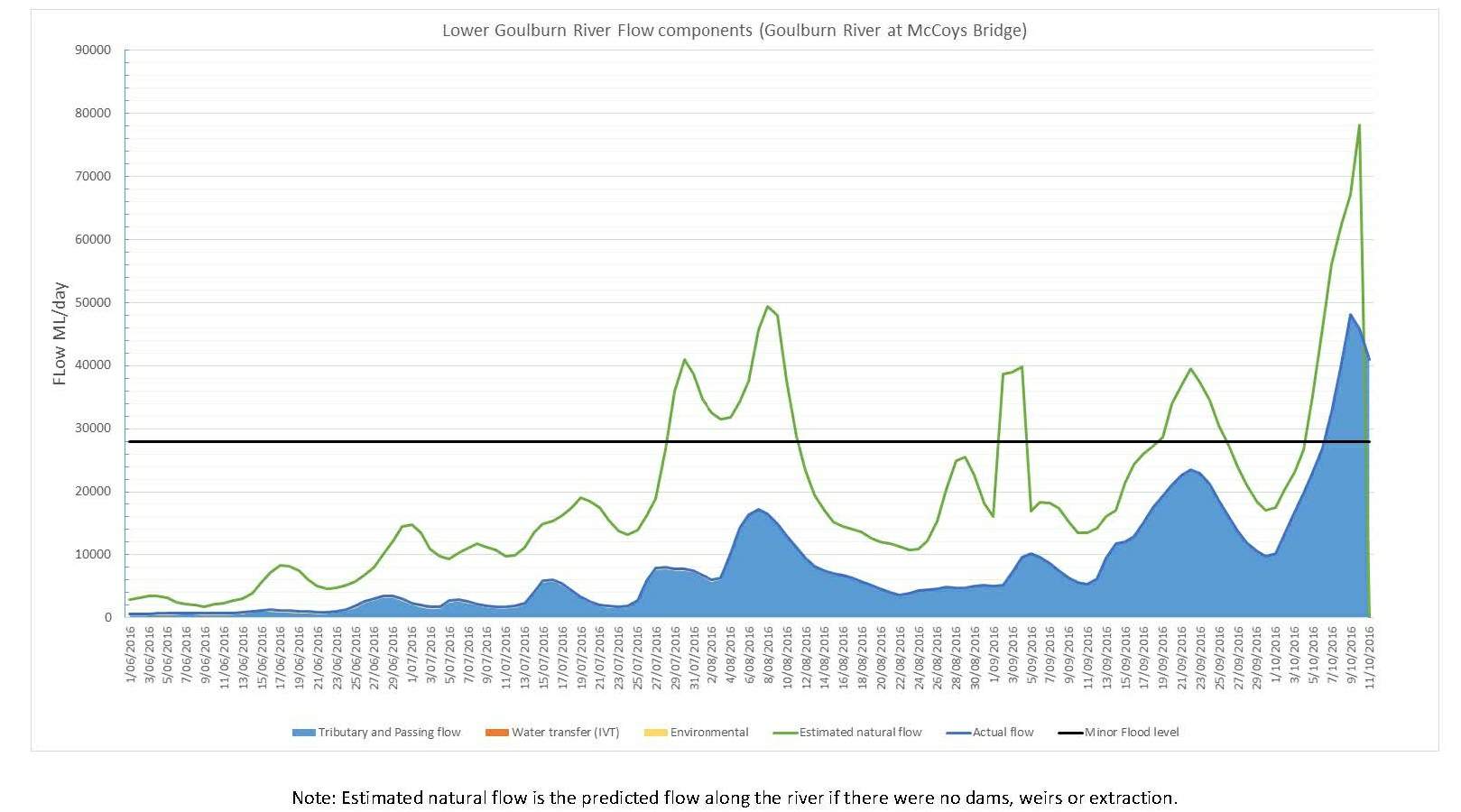
These higher flows along the lower Goulburn River - with peak flows at McCoy’s Bridge of approximately 17,000ML/day (7.6m) in August, 23,000ML/day (8.5m) in September and 48,000 ML/day (9.9m) in October – have provided the Goulburn Broken CMA with an opportunity to see how different river heights and flows affect land and infrastructure such as bridges, roads and levees. This information will help inform flood management and an ongoing investigation into whether environmental water can be used in combination with natural flows to water the lower Goulburn floodplain.
As a result of these natural high flows a proposed environmental flow along the lower Goulburn River in September was cancelled and a proposed environmental flow along the lower Goulburn River next month (November) has also been cancelled.
For the past five years Goulburn Broken CMA has managed delivery of environmental water along the Goulburn River below the Goulburn Weir in spring to help re-establish bank-stabilising vegetation that declined after years of drought followed by major floods in 2010 and 2011.
Monitoring shows that thanks to previous environmental water deliveries, the right kinds of plants had started to grow and spread on the river banks. However, this lower bank vegetation has been underwater since early August. As these plants have not been established long enough to withstand such a prolonged period of inundation, the Goulburn Broken CMA has decided to cancel next month’s environmental flow along the lower Goulburn River to give the bank vegetation a chance to recover.
The proposed November environmental flow along the lower Goulburn River also aimed to stimulate Golden perch migration and spawning. The natural high flows occurring along the lower Murray and Darling rivers are likely to provide suitable conditions for Golden perch migration and spawning, reducing the need for the environmental flow in the Goulburn River.
Barmah: Widespread rainfall across north-east Victoria has seen flow in the Murray River below Yarrawonga recently peak at about 180,000ML/day. This is expected to flood more than 90 per cent of Barmah Forest. This flooding is caused entirely from large natural inflows from the upper catchment. The last three years have been extremely dry and this flooding is a welcome relief to the floodplain vegetation and the animals it supports.
Broken Creek: Flows at Rice’s Weir are the highest they’ve been for at least four years. These flows are natural and are a result of run-off and inflows, not from environmental water deliveries. Once these natural flows stop, a mixture of water on its way to irrigators and other users and environmental water will be used to deliver a minimum flow 250 ML/day to maintain water quality, control azolla and dissolved oxygen levels, and keep the fish ladders open.
Wetlands: Many of our wetlands, including Reedy and Gemmills swamps near Shepparton, Doctors Swamp near Murchison, Kinnairds and Black swamps near Numurkah and Moodie Swamp near Katamatite are full.
Reedy and Gemmills filled as a result of natural flooding across the Goulburn River floodplain while Doctors, Kinnairds and Black swamps captured rainfall run-off. Moodie Swamp had environmental water delivered during April and May, with run-off from recent rain topping it up.
The full wetlands are ideal for native birds such as brolga, who are feeding and preparing for spring breeding.
For more information about environmental water and proposed environmental water deliveries for 2016-17, please visit Goulburn Broken CMA’s website.
Environmental flows are planned by the Goulburn Broken CMA and managed by Goulburn-Murray Water in line with the Victorian Environmental Water Holder’s Seasonal Watering Plan 2016-17.