Residents are invited to attend a second round of community meetings for the Granite Creeks flood study, one of 10 regional scale flood mapping projects underway across the state.
The Victorian Government has provided $1.5 million in funding for this program.
Steve Muncaster, Manager of the Department of Environment Land Water and Planning’s (DELWP) Floodplain Management unit, said community meetings are an important part of the flood mapping program.
“I’d urge Victorians to get involved in the project’s community meetings, as local knowledge is very important in understanding the impacts floods can have in particular areas,” Mr Muncaster said.
“The outputs of these projects will be used to improve land use planning, emergency planning and community preparation for floods, so residents’ knowledge can help their community be better prepared for future flood events.”
The meeting details are:
- Miepoll, Miepoll Hall, 6 pm to 8 pm, Monday 22nd Feb 2016
- Caniambo, Caniambo Hall, 11 am to 1 pm, Tuesday 23rd Feb 2016
- Avenel, Avenel Hall, 3:30 pm to 6 pm, Tuesday 23rd Feb 2016
Previous meetings were held in September of last year and focused on recording community members’ flood stories. For this second round of meetings, community members are invited to drop in to view and comment on flood maps and talk to the project team about how flooding affects them.
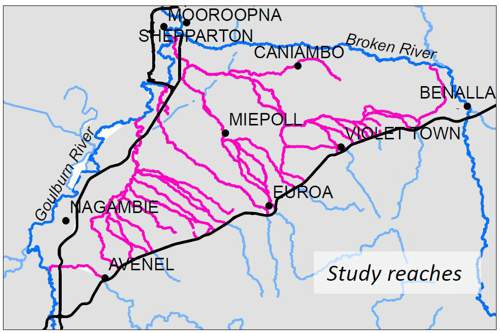
The Granite Creeks describes a number of tributaries of the Goulburn and Broken Rivers that rise from the granite hills of the Strathbogie Ranges. These tributaries include Hughes Creek, Pranjip Creek, Creightons Creek, Castle Creek, Seven Creeks, Faithfull Creek, Honeysuckle Creek and Baddaginnie (Five Mile) Creek.
Regional scale flood mapping projects are underway for the Avon, Goulburn, Fitzroy, Avoca, Loddon, Ovens, Wimmera, Otway, Upper Murray and Snowy catchments. The projects are being managed by DELWP and overseen by local steering committees that include catchment management authorities, local government, VICSES and community representatives.
Community meetings in other areas will be publicised and communities alerted when the meetings are scheduled.
For further information on the Granite Creeks Flood Mapping Project contact Tom O’Dwyer at the Goulburn Broken CMA on (03) 5822 7700.