Good rainfall and run-off across the catchment saw Goulburn River flows at Shepparton peak on July 25 at 10,000ML/day, a river height of just under six metres.
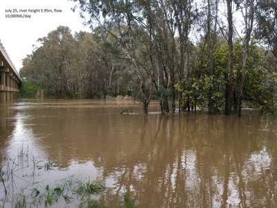
Good rainfall and run-off across the catchment saw Goulburn River flows at Shepparton peak on July 25 at 10,000ML/day, a river height of just under six metres.
The minor flood level is nine metres.
Goulburn Broken Catchment Management Authority (CMA) Environmental Water Manager Simon Casanelia said the increase in the height of the Goulburn River below Goulburn Weir was due to run-off and inflows from tributaries including the Broken River and Seven, Castles and Pranjip creeks.
“A fortnight ago the Goulburn River at Shepparton peaked about five metres before slowly falling to about three metres,” Mr Casanelia said.
“With good run-off due to more steady rain, particularly across the Strathbogies, many of the creeks in that area are continuing to flow really well, which is great news for the fish, plants and animals that rely on them.”
These additional flows from the creeks are ‘topping up’ the environmental base flow of 500ML/day that is being released from Goulburn Weir to the lower Goulburn River.
The higher river flows benefit water bugs, native fish and bank vegetation and take about fours days to reach the Murray River from Shepparton.
Check daily river heights here.